Temperatures in Doncaster could top 40c as heatwave set to peak
and live on Freeview channel 276
Forecasts show we could be in for some recording breaking heat at the start of next week – with the record high of 38.7c recorded in Cambridge in 2019 under threat.
The latest heatwave is expected to hit the UK at the weekend and into early next week and is caused by very hot plume of air coming from Portugal and Spain.
Advertisement
Hide AdAdvertisement
Hide AdTemperatures will steadily rise over the next few days and high pressure will move in on Saturday.

The high pressure moves eastwards which in turn allows a southerly airflow and a vortex will bring extremely hot air over the UK.
Saturday’s temperatures will be mid to high 30s with lots of strong sunlight.
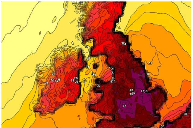
Temperatures on Sunday will be in the low to mid 30s, Monday will see mid to high 30s and Tuesday the heat is expected to peak in the high 30s and could even reach 40c or more.
Advertisement
Hide AdAdvertisement
Hide AdThose are the air temperatures expected, the ‘feel like’ temperature will be much higher due to ground and residue heat from previous days.
Night time temperatures will be mid to high 20s.
There are also signs appearing of a thundery breakdown happening Tuesday into Wednesday but not confirmed as of yet.
Models are subject to change and hopefully there will be a downgrade to this forecast.
The Image is today's UKMO weather run for next Tuesday. It's pretty accurate and one of these the Met Office use.
The current amber alert could be changed to red for Sunday, Monday, Tuesday.