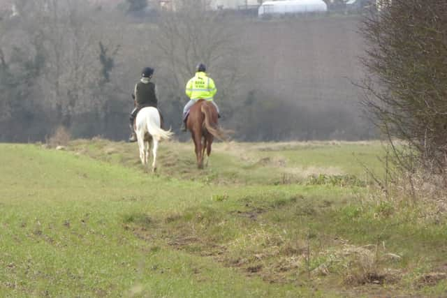
DONCASTER RAMBLERS: It is equine two thirds of the route
and live on Freeview channel 276
This article contains affiliate links. We may earn a small commission on items purchased through this article, but that does not affect our editorial judgement.
As this walk is outside DMBC it should only be done by locals, the rest of us might have to wait until summer, which might not be a bad thing.
We who regularly walk the countryside, are used to livestock churning up the ground, but today it’s equine as two thirds of the route is on bridleways.
Advertisement
Hide AdAdvertisement
Hide Ad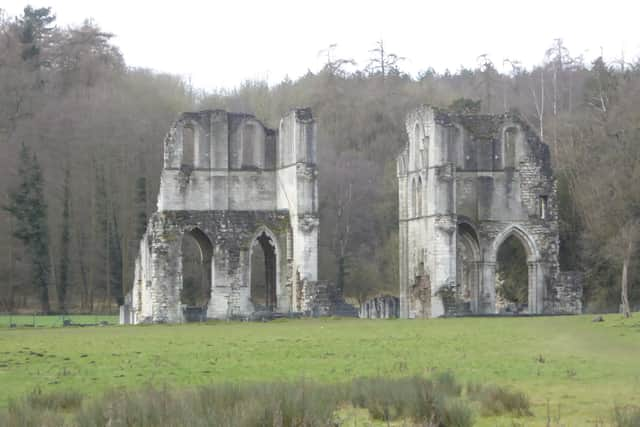

The walk begins about 80m from the Black Lion along New Road to a fingerpost at Flat Lane.
The bridleway continues northerly zigzagging a bit at the start, for just over a mile.
There are a flurry of fingerposts but the general direction is towards the hamlet of Stone.
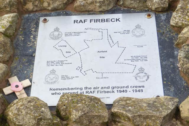
Don’t miss the small memorial to RAF Firbeck.
RAF Firbeck is a former Royal Air Force station.
The airfield was opened in September 1940 and was closed in 1948, during this time it was mainly used an relief landing ground (RLG) and small planes such as the Westland Lysander and the Taylorcraft Auster.
Advertisement
Hide AdAdvertisement
Hide AdAfter the Second World War had ended the airfield was used by two Royal Air Force (RAF) gliding schools.
At Stone cross the bridge and turn left then head uphill to a gate 130m on the left, go through and continue parallel to the A634 crossing King’s Wood Lane and continuing on west getting the first glimpse of Roche Abbey.
Take care as the ground can be flooded from Maltby Dike.
On reaching the Abbey turn left along the fence cross bridge and continue on through Kings Wood stopping to admit the waterfall and remembering to take the left fork as the path splits.
From there it’s about one and a quarter miles to Laughton en le Morthen.
Advertisement
Hide AdAdvertisement
Hide AdThe approach can confuse but where the path splits turn right uphill and at the next junction turn right and exit onto High Street.
Turn left and follow the road round for 450m to another Bridleway sign (Kirk Croft Road)
There now follows a long straight stretch of about two and a halfmiles back to Firbeck the last mile of so on a country road.
At seven miles this is not a short walk, but for those wanting to stretch their legs an easy route to follow.
*Doncaster Ramblers local walks are now available online.
For details visit the website
Advertisement
Hide AdAdvertisement
Hide Adhttps://www.doncasterramblers.org.uk/walks/map-of-walking-routes.html and click on walk name for map or gps icon to download file.
Follow Doncaster Ramblers on Facebook at https://www.facebook.com/doncasterramblers/ for route description.
Please take care when walking and follow the Countryside Code.
Follow government guidelines, you can walk outdoors once a day as part of your daily exercise – by yourself, with members of your household or support bubble, or with one other person. Only walk locally.
In these confusing and worrying times, local journalism is more vital than ever. Thanks to everyone who helps us ask the questions that matter by taking out a subscription or buying a paper. We stand together. Nancy Fielder, editor.
Comment Guidelines
National World encourages reader discussion on our stories. User feedback, insights and back-and-forth exchanges add a rich layer of context to reporting. Please review our Community Guidelines before commenting.